
Home / C3 Property

The C3 Property.

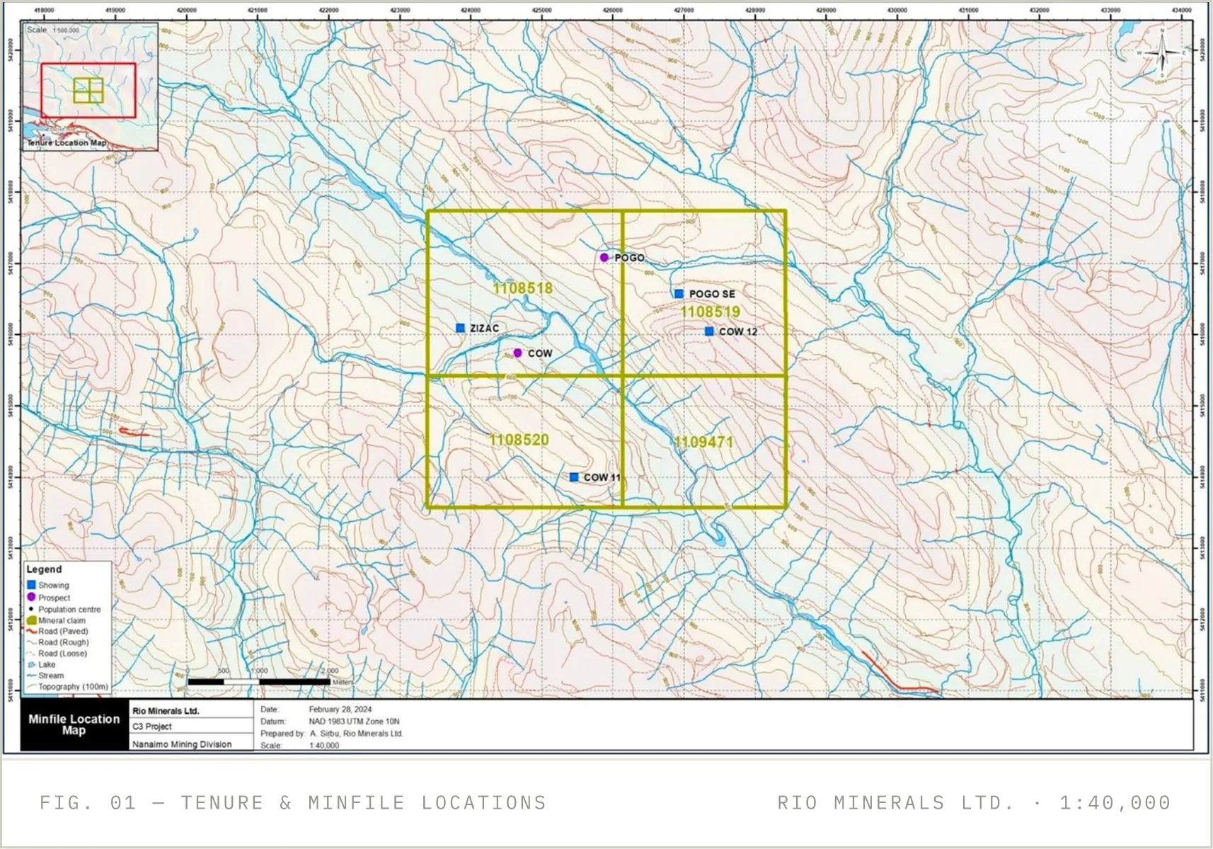
2,102.64 hectares across four contiguous mineral claims in the Cowichan Valley, Vancouver Island — 100% held by Fields of Gold Corp., centred at 48.88° N, 124.00° W on NTS sheets 92C/16 and 92B/13.

27 KM

Northwest of Duncan, B.C.

4

Contiguous Mineral Claims

6

Documented Minfile Showings

1964

First Claims Staked on Ground

01

Access is via the all-weather Chemainus Main logging road off Highway 1, with smaller logging roads reaching much of the property under a gate- access agreement with Mosaic Forest Management.
The maritime climate keeps winters mild and the exploration season effectively year-round. Duncan (27 km) provides local services; Nanaimo (76 km) offers a deep-water port and mining services; Victoria International Airport is 106 km away. Extensive recent logging has opened new road access and improved ground visibility across the claims.
02

MINERAL CLAIMS — REGISTERED 100% TO FIELDS OF GOLD CORP.

Title No.
Claim Name
Issue Date
Area (ha)
1108518
C-1
2023-10-24
637.02
1108519
C-2
2023-10-24
530.91
1108520
C3
2023-10-24
509.82
1109471
C3-4
2023-12-08
424.89
Total contiguous land position
2,102.64

Tenure confirmed on the B.C. Mineral Titles Online registry as at the technical report date. Surface rights over the property are privately held; the technical report sets out the applicable access and notification regime.

03
The property lies within the Wrangellia Terrane of southern Vancouver Island. It is underlain by cherty argillites of the Mississippian– Pennsylvanian Fourth Lake Formation and volcaniclastics of the Upper Devonian McLaughlin Ridge Formation, intruded by granodiorite and quartz diorite of the Jurassic Island Plutonic Suite and by Triassic gabbro.
Sulphide mineralization — pyrite, chalcopyrite, with local galena and sphalerite — occurs in rusty shear zones as disseminations and stringers along bedding, cleavage, and crosscutting fractures, and in quartz-carbonate veins spatially associated with gabbroic dykes. Alteration styles observed in 2024, including sericitization with sulphides, suggest a potentially hydrothermal Cu–Au system.
04
MINFILE

Cow 12 / C3

Additional documented occurrences within the claim block, detailed in the technical report and provincial Minfile records.
092C 193

Zizac

Weathered quartz-vein system with intense silica– sericite–fuchsite alteration and massive sulphide pods; anomalous gold.
092B 167

Pogo SE

Heavily oxidized zones in gabbro and diorite; a lone grab assayed 0.72% Zn, 0.17% Pb, and 0.13% Cu.
092C 074

Pogo

Pyrrhotite–pyrite–chalcopyrite in a fractured gabbroic dyke intruding cherty argillite, pinched at a synclinal fold axis.
092C 190

Cow 11

Rusty gossanous diorite; a 1992 grab sample assayed 13.0 g/t Au, 14.7 g/t Ag, and 3,376 ppm Cu.
092C 192

Cow

Polymetallic Ag–Pb–Zn–Au quartz vein in an east- trending shear; historical grabs to 13.03 g/t Au and 29.4 g/t Ag. Focus of the strongest 2024 results.
05

ROCK SAMPLES — COW SHOWING AREA, 2024 PROGRAM

Sample
Au g/t
Ag ppm
Cu ppm
Pb %
Zn %
181430
48.0
13.3
1,140
_
_
181432
24.7
79.0
1,050
1.79
2.01
181424
10.6
5.3
964
_
_
181423
9.07
9.0
1,470
_
_
181425
5.80
_
_
_
_
181422
2.44
_
_
_
_

Grab and chip samples are selective and not necessarily representative. Analyses by Activation Laboratories, Kamloops (ISO/IEC 17025). The Qualified Person’s independent verification samples at the same sites returned values of up to 53.2 g/t Au. Source: NI 43-101 Technical Report, effective May 22, 2024.

Qualified Person

Scientific and technical information on this page is qualified in its entirety by the “NI 43-101 Technical Report on the C3 Property, British Columbia,” prepared by Derrick Strickland, P.Geo., effective May 22, 2024. No mineral resource or mineral reserve has been estimated on the property.